La Niña and El Niño Dance
Air Date: January 17, 2025
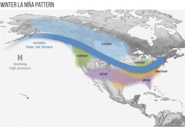
With the recent appearance of a flip from an El Niño back to a weak La Niña climate pattern, Hosts Aynsley O’Neill and Jenni Doering discuss what it could mean for U.S. and world weather patterns, as well as how the El Niño / La Niña oscillation is changing in the era of climate disruption.
- 1La Niña and El Niño Dance
Transcript
DOERING: Alongside the long-term trend of climate disruption, there are climate patterns that can enhance or sometimes mask the overall warming climate. One of these cycles is a phenomenon known as the El Niño Southern Oscillation. El Niño is Spanish for “little boy,” and it’s called that because it usually arises in the Pacific Ocean off the coast of South America sometime around the longest day of the year in the southern hemisphere. That’s also right around when Christians celebrate the birth of the “Christ child.” Some years, warmer-than-average temperatures spell an El Niño, and in others colder-than-average temperatures mean a La Niña. And Aynsley, you’ve been taking a look into the news that we’ve just entered La Niña and what that means for the climate. So, what did you find?
O’NEILL: Yeah Jenni, we’ve just recently dipped from neutral territory into a weak La Niña, meaning that the sea surface temperature is 0.5 degrees Celsius colder than average. When seas are 1 degree colder than usual, that’s a moderate La Niña, and so on, and so forth.
DOERING: Okay, so if we’re in a weak La Niña, it must not be that intense right now.
O’NEILL: Right, although as with everything it’s a little more complicated. Climate expert Kevin Trenberth is now retired from a career with the US National Center for Atmospheric Research. And he wrote to me that in many ways it actually looks like a more moderate La Niña, because the rest of the sea temperatures are above what we consider normal due to the warming planet.
DOERING: Huh, makes sense. What’s ‘average’ is changing now. So, what does this La Niña mean for the weather we see not just in the ocean, but on land?
O’NEILL: Well, one of these events dictates a lot regarding rainfall patterns.
So, in North America, we’re seeing wetter conditions in the pacific northwest and up to British Columbia, and drier conditions in the American southwest.
DOERING: And there would also be an impact on temperature, right?
O’NEILL: Yeah, generally speaking, winter temperatures are going to be cooler than normal in the Northern U.S. and warmer than normal in the Southern U.S. Those changes are at their peak between November and February - which is why you’ll usually see one of these events listed under two years. And the cold La Niña events will often double- or triple-dip, lasting for two or three years, but El Niño tends to stick to one.
DOERING: Hmm. I can’t help but think that La Niña with its hotter, drier weather doesn’t sound like good news for Southern California and the terrible wildfires there right now.
O’NEILL: No, not at all.
DOERING: And of course, this La Niña is unfolding in an ever-changing climate.
O’NEILL: That’s right, and while scientists aren’t sure exactly how climate disruption is impacting the El Niño / La Niña cycle, warming global temperatures are definitely resulting in more intense effects of an El Niño or La Niña. Droughts are drier, rainy seasons are wetter.
DOERING: Hmm.
O’NEILL: And just because La Niña means colder-than-average ocean surface temperatures doesn’t mean that it’s reversing global warming or anything - if you look at the NOAA data, you can see that the ocean surface temperatures during recent La Niña years are actually warmer than for the El Niño years in earlier decades.
DOERING: So, La Niña won’t necessarily bring a reprieve from the record-breaking temperatures we saw in 2024.
O’NEILL: Nope – so, we are likely in for another very hot year in 2025.
DOERING: Ugh. Indeed.